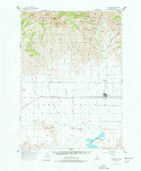
1957 Map of Fairfield
USGS Topo · Published 1978About this map
Fairfield stands as the central hub of this Camas County landscape, situated where the northern slopes of Soldier Mountain meet the high prairie. The map documents a transition from the alpine reaches of the Soldier Mountain Game Preserve, featuring high peaks like Smoky Dome, to the irrigated agricultural lands of Davis Flat. Cultural markers including Mtn View Cemetery and Corral Cemetery offer specific points of interest for genealogists, while the presence of the Richard Allen Mine and several forest camps like Pioneer Forest Camp speak to the region's history of extraction and recreation. The southern portion of the sheet is dominated by the waters of Mormon Reservoir and the winding course of Camas Creek, illustrating the vital role of water management in this high-altitude environment during the late 1950s.
Find a feature on this map
66 named features on this map. Tap any name to fly to it.
Don’t see what you’re looking for? This feature index may not catch every label — zoom into the map to look around manually.
Map Details
Editions of this 1957 Fairfield Map
2 editions found
Other maps of this area

1892 · Camas Prairie
USGS Topo · 1:125,000

1893 · Camas Prairie
USGS Topo · 1:125,000

1894 · Rocky Bar
USGS Topo · 1:125,000

1900 · Sawtooth
USGS Topo · 1:125,000

1955 · Hailey
USGS Topo · 1:250,000

1957 · Fairfield
USGS Topo · 1:62,500

1957 · Thorn Creek
USGS Topo · 1:62,500

1957 · Davis Mountain
USGS Topo · 1:62,500

1957 · Blaine
USGS Topo · 1:62,500

1958 · King Hill
USGS Topo · 1:62,500