
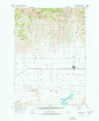
1957 Map of Fairfield
USGS Topo · Published 1958About this map
Fairfield stands as the central hub of this agricultural landscape in the late 1950s, situated where the broad Camas Prairie meets the southern slopes of the Soldier Mountains. The settlement pattern follows the Pacific Union railroad line and the Boise Base Line, reflecting a mid-century economy built on ranching and transport. To the north, the terrain rises sharply into the Sawtooth National Forest and Game Preserve, featuring the Richard Allen Mine and recreational spots like Pioneer Forest Camp.
Find a feature on this map
62 named features on this map. Tap any name to fly to it.
Don’t see what you’re looking for? This feature index may not catch every label — zoom into the map to look around manually.
Map Details
Editions of this 1957 Fairfield Map
2 editions found
Other maps of this area

1892 · Camas Prairie
USGS Topo · 1:125,000

1893 · Camas Prairie
USGS Topo · 1:125,000

1894 · Rocky Bar
USGS Topo · 1:125,000

1900 · Sawtooth
USGS Topo · 1:125,000

1955 · Hailey
USGS Topo · 1:250,000

1957 · Thorn Creek
USGS Topo · 1:62,500

1957 · Davis Mountain
USGS Topo · 1:62,500

1957 · Blaine
USGS Topo · 1:62,500

1958 · King Hill
USGS Topo · 1:62,500

1959 · Hailey
USGS Topo · 1:250,000