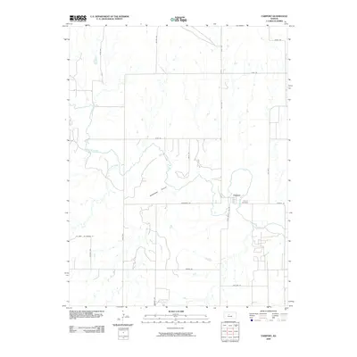
2009 Map of Fairport
USGS Topo · Published 2009About this map
Fairport sits at the eastern edge of Russell County, where the Saline River winds through a landscape marked by deep incisions like Sweetwater Canyon. This 2009 survey reflects the rural character of the Kansas plains, dominated by a strict grid of section roads including Severin Rd and Mellard Rd that service agricultural tracts. The settlement itself remains centered near the river crossing, with the Fairport Cemetery located just to the east along Fairport Rd. The western boundary of the map is defined by Ellis County Line Rd, marking the transition between counties. Local drainage is defined by the convergence of Sweetwater Creek and the river, creating the varied topography seen in the canyonlands before the terrain flattens into the expansive uplands along Homestead Rd.
Find a feature on this map
23 named features on this map. Tap any name to fly to it.
Don’t see what you’re looking for? This feature index may not catch every label — zoom into the map to look around manually.
Map Details
Editions of this 2009 Fairport Map
This is the sole edition of this map. No revisions or reprints were ever made.
Other maps of this area
1896 · Osborne
USGS Topo · 1:125,000
1896 · Russell
USGS Topo · 1:125,000
1896 · Hays
USGS Topo · 1:125,000
1896 · Plainville
USGS Topo · 1:125,000

1955 · Great Bend
USGS Topo · 1:250,000

1955 · Beloit
USGS Topo · 1:250,000

1957 · Great Bend
USGS Topo · 1:250,000

1958 · Great Bend
USGS Topo · 1:250,000

1959 · Beloit
USGS Topo · 1:250,000
1961 · Catharine
USGS Topo · 1:24,000