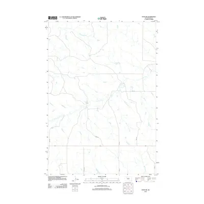
2012 Map of Faith SW
USGS Topo · Published 2012About this map
Flint Rock Cr and its many unnamed tributaries weave through this section of Meade County, creating a dendritic drainage pattern typical of the South Dakota plains. The landscape is defined by its wide-open ranching character, where the human footprint is primarily marked by a strictly aligned section-line road grid. Notable thoroughfares include Viking Rd and 161st Ave, which provide access to this expansive prairie terrain. In the southern portion of the map, Wagon Rd and the crossing of Red Scaffold Cr indicate the sparse but essential network connecting remote homesteads. The infrastructure here, including Co Hwy Mc-37, underscores the transition of old prairie trails into the modern rural highway system maintained by the U.S. Geological Survey in the early 21st century.
Find a feature on this map
10 named features on this map. Tap any name to fly to it.
Don’t see what you’re looking for? This feature index may not catch every label — zoom into the map to look around manually.
Map Details
Editions of this 2012 Faith SW Map
This is the sole edition of this map. No revisions or reprints were ever made.
Other maps of this area

1951 · Faith NE
USGS Topo · 1:24,000

1952 · Deep Creek SE
USGS Topo · 1:24,000

1952 · Deep Creek NE
USGS Topo · 1:24,000

1952 · Faith NW
USGS Topo · 1:24,000

1953 · Rapid City
USGS Topo · 1:250,000

1954 · Lemmon
USGS Topo · 1:250,000

1957 · Lemmon
USGS Topo · 1:250,000

1957 · Rapid City
USGS Topo · 1:250,000
1983 · Faith
USGS Topo · 1:24,000

1983 · Lemmon Butte
USGS Topo · 1:24,000