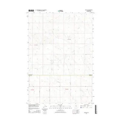
2015 Map of Faith SW
USGS Topo · Published 2015About this map
The Perkins County and Meade County border divides this 2015 survey of the South Dakota prairie, a landscape defined by its network of intermittent waterways and established section lines. The drainage of Flint Rock Cr dominates the northern half of the quadrangle, while Red Scaffold Cr cuts through the southeastern corner. This area reflects the enduring Public Land Survey System structure, with topographic data from the U.S. Geological Survey illustrating the subtle elevation changes of the Great Plains. The road network follows the rigorous logic of the grid, with routes like 191st Ave and 161st St providing access to this agricultural and ranching region. Traditional named thoroughfares such as Wagon Rd and Avance Rd cross the section lines, suggesting older travel patterns that predated the strict cardinal-direction grid.
Find a feature on this map
15 named features on this map. Tap any name to fly to it.
Don’t see what you’re looking for? This feature index may not catch every label — zoom into the map to look around manually.
Map Details
Editions of this 2015 Faith SW Map
This is the sole edition of this map. No revisions or reprints were ever made.
Other maps of this area

1951 · Faith NE
USGS Topo · 1:24,000

1952 · Deep Creek SE
USGS Topo · 1:24,000

1952 · Deep Creek NE
USGS Topo · 1:24,000

1952 · Faith NW
USGS Topo · 1:24,000

1953 · Rapid City
USGS Topo · 1:250,000

1954 · Lemmon
USGS Topo · 1:250,000

1957 · Lemmon
USGS Topo · 1:250,000

1957 · Rapid City
USGS Topo · 1:250,000
1983 · Faith
USGS Topo · 1:24,000

1983 · Lemmon Butte
USGS Topo · 1:24,000