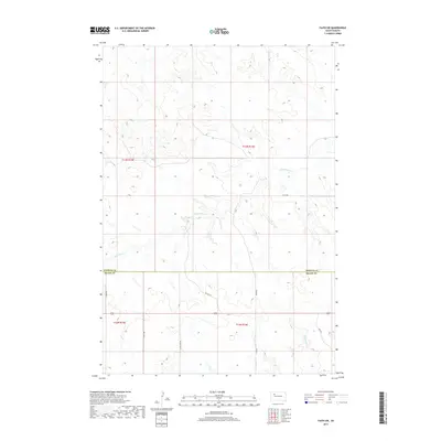
2017 Map of Faith SW
USGS Topo · Published 2017About this map
The Perkins Co Meade Co boundary line divides this prairie landscape, where the drainage systems of Flint Rock Cr and Red Scaffold Cr carve intricate patterns into the high plains. The topography is defined by the transition between several townships, including t13n r15e and t12n r16e, showcasing the geometric precision of the Public Land Survey System against the natural winding paths of the local creeks. Transportation in this part of western South Dakota is anchored by a network of rural routes, ranging from established thoroughfares like Co Hwy Mc-37 and Tower Rd to historically evocative paths such as Wagon Rd. This layout reflects a modern ranching and agricultural region that still follows the foundational trails and section lines established during early settlement.
Find a feature on this map
15 named features on this map. Tap any name to fly to it.
Don’t see what you’re looking for? This feature index may not catch every label — zoom into the map to look around manually.
Map Details
Editions of this 2017 Faith SW Map
This is the sole edition of this map. No revisions or reprints were ever made.
Other maps of this area

1951 · Faith NE
USGS Topo · 1:24,000

1952 · Deep Creek SE
USGS Topo · 1:24,000

1952 · Deep Creek NE
USGS Topo · 1:24,000

1952 · Faith NW
USGS Topo · 1:24,000

1953 · Rapid City
USGS Topo · 1:250,000

1954 · Lemmon
USGS Topo · 1:250,000

1957 · Lemmon
USGS Topo · 1:250,000

1957 · Rapid City
USGS Topo · 1:250,000
1983 · Faith
USGS Topo · 1:24,000

1983 · Lemmon Butte
USGS Topo · 1:24,000