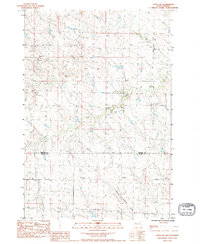
1983 Map of Faith SW
USGS Topo · Published 1984About this map
Flint Rock Creek and Red Scaffold Creek meander through this portion of the northern Great Plains, marking a landscape defined by its watercourses and open range. Surveyed in the early 1980s, the terrain straddles the boundary of Perkins and Meade counties. The map captures specialized topographical details such as Timber In Water, suggesting localized wooded pockets along the creek beds that contrast with the surrounding high ground. Infrastructure is sparse, characterized by a Trans Line Wooden Pole that underscores the rural utility development of this era. The lack of named settlements or major thoroughfares emphasizes the pastoral, unpopulated nature of this prairie region, where drainage patterns and property lines form the primary landmarks for local history and land management.
Find a feature on this map
5 named features on this map. Tap any name to fly to it.
Don’t see what you’re looking for? This feature index may not catch every label — zoom into the map to look around manually.
Map Details
Editions of this 1983 Faith SW Map
This is the sole edition of this map. No revisions or reprints were ever made.
Other maps of this area

1951 · Faith NE
USGS Topo · 1:24,000

1952 · Deep Creek SE
USGS Topo · 1:24,000

1952 · Deep Creek NE
USGS Topo · 1:24,000

1952 · Faith NW
USGS Topo · 1:24,000

1953 · Rapid City
USGS Topo · 1:250,000

1954 · Lemmon
USGS Topo · 1:250,000

1957 · Lemmon
USGS Topo · 1:250,000

1957 · Rapid City
USGS Topo · 1:250,000
1983 · Faith
USGS Topo · 1:24,000

1983 · Lemmon Butte
USGS Topo · 1:24,000