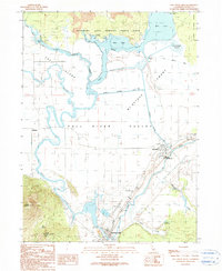
1990 Map of Fall River Mills
USGS Topo · Published 1990About this map
The confluence of the Fall River and Pit River defines the agricultural and industrial landscape of this northeastern California valley. In 1990, the towns of Fall River Mills and McArthur serve as central hubs, connected by a network of levees and irrigation systems including the Mc Arthur Diversion Canal and Shelly Ditch. The presence of the Pit 1 Dam and Pit 1 Intake reflects the importance of water management and power generation to the local economy. To the north, the terrain transitions into the distinct volcanic features of Ahjumawi Lava Springs State Park, where Crystal Springs and Horr Pond sit at the edge of vast lava flows.
Find a feature on this map
47 named features on this map. Tap any name to fly to it.
Don’t see what you’re looking for? This feature index may not catch every label — zoom into the map to look around manually.
Map Details
Editions of this 1990 Fall River Mills Map
This is the sole edition of this map. No revisions or reprints were ever made.
Other maps of this area

1886 · Lassen Peak
USGS Topo · 1:250,000

1886 · Modoc Lava Bed
USGS Topo · 1:250,000

1892 · Modoc Lava-Bed
USGS Topo · 1:250,000

1892 · Lassen Peak
USGS Topo · 1:250,000

1894 · Lassen Peak
USGS Topo · 1:250,000

1932 · Bartle
USGS Topo · 1:96,000

1935 · Burney
USGS Topo · 1:96,000

1939 · Burney
USGS Topo · 1:125,000

1939 · Halls Flat
USGS Topo · 1:125,000

1939 · Bartle
USGS Topo · 1:125,000