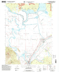
1995 Map of Fall River Mills
USGS Topo · Published 1998About this map
Ahjumawi Lava Springs State Park preserves a complex volcanic landscape where the Little Tule River and Fall River converge in the Fall River Valley. This mid-1990s record documents the hydraulic infrastructure of the region, including the Mc Arthur Diversion Canal and the levees surrounding The Island. The town of Fall River Mills is a focal point of commerce and health services, featuring the Fall River Mills Airport and local Hospital. Further east, the community of McArthur serves as a civic hub with the Intermountain Fairgrounds and the Fall River Jr & Sr High Sch. The map reveals the intricate water network feeding into Big Lake and Hollenbeak Swamp, contrasting the flat, fertile valley floor against the rising slopes of Saddle Mountain and Haney Mountain to the southwest.
Find a feature on this map
38 named features on this map. Tap any name to fly to it.
Don’t see what you’re looking for? This feature index may not catch every label — zoom into the map to look around manually.
Map Details
Editions of this 1995 Fall River Mills Map
This is the sole edition of this map. No revisions or reprints were ever made.
Other maps of this area

1886 · Lassen Peak
USGS Topo · 1:250,000

1886 · Modoc Lava Bed
USGS Topo · 1:250,000

1892 · Modoc Lava-Bed
USGS Topo · 1:250,000

1892 · Lassen Peak
USGS Topo · 1:250,000

1894 · Lassen Peak
USGS Topo · 1:250,000

1932 · Bartle
USGS Topo · 1:96,000

1935 · Burney
USGS Topo · 1:96,000

1939 · Burney
USGS Topo · 1:125,000

1939 · Halls Flat
USGS Topo · 1:125,000

1939 · Bartle
USGS Topo · 1:125,000