1949 Map of Fallbrook
USGS Topo · Published 1957About this map
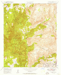
Camp Joseph H Pendleton Naval Reservation dominates the lower half of this landscape, reflecting the military expansion into Southern California during the mid-century. The terrain is defined by complex drainage systems where De Luz Creek and Cottonwood Creek feed into the Santa Margarita River. Beyond the military boundaries, a series of private holdings like Johnson Ranch, Sky Ranch, and Merchant Ranch illustrate the area's rural character before the rapid suburbanization of later decades. The small community of De Luz is visible with its De Luz Sch, while the growing town of Fallbrook appears in the southeast corner. Prominent elevations such as Redonda Mesa and Rocky Peak provide clear landmarks within the Cleveland National Forest, showing a region still defined by its natural topography and agricultural roots.
Find a feature on this map
30 named features on this map. Tap any name to fly to it.
Don’t see what you’re looking for? This feature index may not catch every label — zoom into the map to look around manually.
Map Details
Editions of this 1949 Fallbrook Map
3 editions found
Other maps of this area

1901 · Southern California Sheet No. 1
USGS Topo · 1:250,000

1901 · Elsinore
USGS Topo · 1:125,000

1901 · San Luis Rey
USGS Topo · 1:125,000

1904 · Southern California Sheet No. 2
USGS Topo · 1:250,000

1904 · Southern California Sheet No. 1
USGS Topo · 1:250,000

1941 · Margarita Peak
USGS Topo · 1:62,500

1942 · Lake Elsinore
USGS Topo · 1:62,500

1942 · Margarita Peak
USGS Topo · 1:62,500

1942 · Temecula
USGS Topo · 1:62,500

1942 · Murrieta
USGS Topo · 1:62,500
Featured Places
- Fallbrook, CA
- Marine Corps Base Camp Pendleton, CA
- Santa Margarita Groves, CA
- De Luz Heights, CA
- De Luz, CA