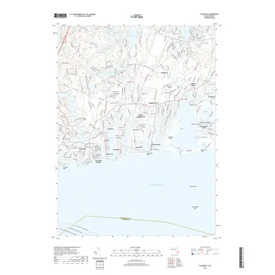
2018 Map of Falmouth
USGS Topo · Published 2018About this map
The glacial landscape of the Upper Cape is defined by its numerous kettle ponds and deeply indented coastline, where residential expansion centers around historic cores like Falmouth and East Falmouth. This modern topographic perspective reveals a complex network of coastal necks and islands, including Washburn Island and Monomoscoy Island, which guard the inlets of the Atlantic coast. The map meticulously documents local burial grounds, such as Waquoit Cem and Saint Joseph's Cem, providing a precise spatial record for genealogical research. Inland, the distribution of water bodies like Coonamessett Pond and Johns Pond highlights the region's reliance on its freshwater resources and protected harbors. Maritime connections are emphasized through the paths of the Martha's Vineyard and Woods Hole Ferry, linking the mainland to the islands across the sounds.
Find a feature on this map
74 named features on this map. Tap any name to fly to it.
Don’t see what you’re looking for? This feature index may not catch every label — zoom into the map to look around manually.
Map Details
Editions of this 2018 Falmouth Map
This is the sole edition of this map. No revisions or reprints were ever made.
Other maps of this area

1886 · Falmouth
USGS Topo · 1:62,500

1887 · Marthas Vineyard
USGS Topo · 1:62,500

1888 · Barnstable
USGS Topo · 1:62,500

1888 · Falmouth
USGS Topo · 1:62,500

1889 · Marthas Vineyard
USGS Topo · 1:62,500

1893 · Barnstable
USGS Topo · 1:62,500

1893 · Falmouth
USGS Topo · 1:62,500

1894 · Marthas Vineyard
USGS Topo · 1:62,500

1915 · Falmouth
USGS Topo · 1:62,500

1920 · Falmouth
USGS Topo · 1:62,500