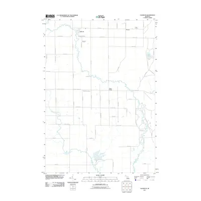
2011 Map of Falmouth
USGS Topo · Published 2011About this map
The Clam River and its West Branch Clam River define the agricultural landscape of Clam Union Township in Missaukee County. This 2011 survey documents a community anchored by three small settlements: Falmouth, Vogel Center, and Prosper. The layout of the region is strictly structured by a grid of rural roads, many bearing family names that provide significant value for local genealogical research. Historically significant landmarks such as the Falmouth Post Office and the Clam Union Cemetery serve as focal points for these tight-knit rural communities. To the northeast, the terrain softens around Dyer Lake, while Mosquito Creek feeds into the main river system. The presence of three distinct cemeteries, including Prosper Cemetery and Vogel Center Cemetery, suggests a long-standing pattern of settlement and localized community identity in this part of Michigan.
Find a feature on this map
55 named features on this map. Tap any name to fly to it.
Don’t see what you’re looking for? This feature index may not catch every label — zoom into the map to look around manually.
Map Details
Editions of this 2011 Falmouth Map
This is the sole edition of this map. No revisions or reprints were ever made.
Other maps of this area

1954 · Traverse City
USGS Topo · 1:250,000

1956 · Houghton Lake
USGS Topo · 1:62,500

1956 · Lake City
USGS Topo · 1:62,500

1957 · Harrison
USGS Topo · 1:62,500

1957 · Marion
USGS Topo · 1:62,500

1958 · Traverse City
USGS Topo · 1:250,000

1983 · Cadillac
USGS Topo · 1:100,000
1983 · Temple
USGS Topo · 1:25,000

1983 · Moddersville
USGS Topo · 1:25,000

1983 · Lake City
USGS Topo · 1:25,000