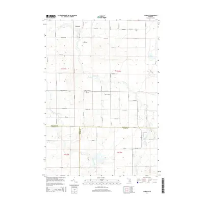
2014 Map of Falmouth
USGS Topo · Published 2014About this map
The Clam River and its West Branch Clam River define the agricultural landscape of Clam Union Township in Missaukee County. This 2014 survey documents a region rooted in its rural settlements, with the village of Falmouth situated at a bend in the river near Union Cem. To the southeast, Vogel Center and Prosper serve as local anchors, each associated with its own namesake cemetery, Vogel Center Cem and Prosper Cem. The map illustrates a strictly organized section-line road network, including S 8 Mile Rd and W Stoney Corners Rd, which provides access to the scattered farmsteads and small water bodies like Dyer Lake. The southern edge of the sheet marks the convergence of three counties—Missaukee, Osceola, and Clare—providing a clear view of how political boundaries align with the township's surveyed grid.
Find a feature on this map
64 named features on this map. Tap any name to fly to it.
Don’t see what you’re looking for? This feature index may not catch every label — zoom into the map to look around manually.
Map Details
Editions of this 2014 Falmouth Map
This is the sole edition of this map. No revisions or reprints were ever made.
Other maps of this area

1954 · Traverse City
USGS Topo · 1:250,000

1956 · Houghton Lake
USGS Topo · 1:62,500

1956 · Lake City
USGS Topo · 1:62,500

1957 · Harrison
USGS Topo · 1:62,500

1957 · Marion
USGS Topo · 1:62,500

1958 · Traverse City
USGS Topo · 1:250,000

1983 · Cadillac
USGS Topo · 1:100,000
1983 · Temple
USGS Topo · 1:25,000

1983 · Moddersville
USGS Topo · 1:25,000

1983 · Lake City
USGS Topo · 1:25,000