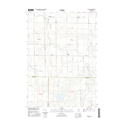
2017 Map of Falmouth
USGS Topo · Published 2017About this map
Clam River and its West Branch Clam River wind through this central Michigan landscape, defining the rural character of Clam Union Township. The settlement of Falmouth serves as a primary hub, situated near the river's bend and featuring the Clam Union Cem. Further east, the community of Vogel Center and the smaller Prosper area reveal a grid of agricultural land and early settlement markers, including the Vogel Center Cem and Prosper Cem. The terrain is characterized by low-lying wetland features like Ballard Swamp and the secluded Dyer Lake. Spanning the borders of Missaukee, Osceola, and Clare counties, the map documents a resilient rural infrastructure of township roads such as S 7 Mile Rd and W Stoney Corners Rd, which connect these historic farming and river-side communities.
Find a feature on this map
64 named features on this map. Tap any name to fly to it.
Don’t see what you’re looking for? This feature index may not catch every label — zoom into the map to look around manually.
Map Details
Editions of this 2017 Falmouth Map
This is the sole edition of this map. No revisions or reprints were ever made.
Other maps of this area

1954 · Traverse City
USGS Topo · 1:250,000

1956 · Houghton Lake
USGS Topo · 1:62,500

1956 · Lake City
USGS Topo · 1:62,500

1957 · Harrison
USGS Topo · 1:62,500

1957 · Marion
USGS Topo · 1:62,500

1958 · Traverse City
USGS Topo · 1:250,000

1983 · Cadillac
USGS Topo · 1:100,000
1983 · Temple
USGS Topo · 1:25,000

1983 · Moddersville
USGS Topo · 1:25,000

1983 · Lake City
USGS Topo · 1:25,000