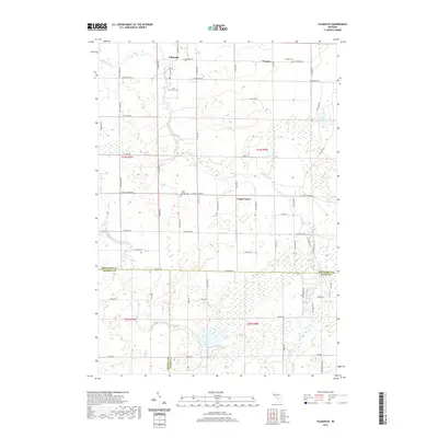
2019 Map of Falmouth
USGS Topo · Published 2019About this map
Falmouth serves as the primary settlement in this corner of Missaukee County, situated near the headwaters of the Clam River. The landscape is defined by the winding paths of the river and its West Branch Clam River, which cut through a terrain of agricultural plots and wetlands such as Ballard Swamp. The settlement patterns of the late 20th and early 21st centuries are evident in the concentration of local community centers like Prosper and Vogel Center, each anchored by its respective burial ground: Prosper Cem and Vogel Center Cem. Genealogists may find value in the inclusion of Clam Union Cem, reflecting the early township organization. The road network, including S Koopman Rd and Meyering Rd, follows a rigid section line grid typical of Michigan's rural interior, providing access between the small farmsteads and the natural features like Dyer Lake.
Find a feature on this map
62 named features on this map. Tap any name to fly to it.
Don’t see what you’re looking for? This feature index may not catch every label — zoom into the map to look around manually.
Map Details
Editions of this 2019 Falmouth Map
This is the sole edition of this map. No revisions or reprints were ever made.
Other maps of this area

1954 · Traverse City
USGS Topo · 1:250,000

1956 · Houghton Lake
USGS Topo · 1:62,500

1956 · Lake City
USGS Topo · 1:62,500

1957 · Harrison
USGS Topo · 1:62,500

1957 · Marion
USGS Topo · 1:62,500

1958 · Traverse City
USGS Topo · 1:250,000

1983 · Cadillac
USGS Topo · 1:100,000
1983 · Temple
USGS Topo · 1:25,000

1983 · Moddersville
USGS Topo · 1:25,000

1983 · Lake City
USGS Topo · 1:25,000