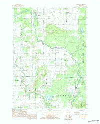
1983 Map of Falmouth
USGS Topo · Published 1984About this map
Falmouth sits at the junction of the Clam River and its north branch, serving as a focal point for the agricultural and natural resources of the Michigan panhandle in the early 1980s. The landscape is defined by the winding course of the river through Clam Union and Riverside, where small settlements like Vogel Center and Prosper maintain community anchors such as Prosper Ch and the Clam Union Cem. This era shows a transition toward resource extraction, evidenced by the Oil and Gas Field appearing near the southern boundary in Winterfield. Large tracts of the Pere Marquette State Forest and Au Sable State Forest dominate the eastern and southern edges of the map, suggesting a region where commercial timber, energy exploration, and rural farming coexist. Significant wetlands like Ballard Swamp and lakes such as Dyer Lake emphasize the low-lying, water-rich character of the terrain.
Find a feature on this map
38 named features on this map. Tap any name to fly to it.
Don’t see what you’re looking for? This feature index may not catch every label — zoom into the map to look around manually.
Map Details
Editions of this 1983 Falmouth Map
This is the sole edition of this map. No revisions or reprints were ever made.
Other maps of this area

1954 · Traverse City
USGS Topo · 1:250,000

1956 · Houghton Lake
USGS Topo · 1:62,500

1956 · Lake City
USGS Topo · 1:62,500

1957 · Harrison
USGS Topo · 1:62,500

1957 · Marion
USGS Topo · 1:62,500

1958 · Traverse City
USGS Topo · 1:250,000

1983 · Cadillac
USGS Topo · 1:100,000
1983 · Temple
USGS Topo · 1:25,000

1983 · Moddersville
USGS Topo · 1:25,000

1983 · Lake City
USGS Topo · 1:25,000