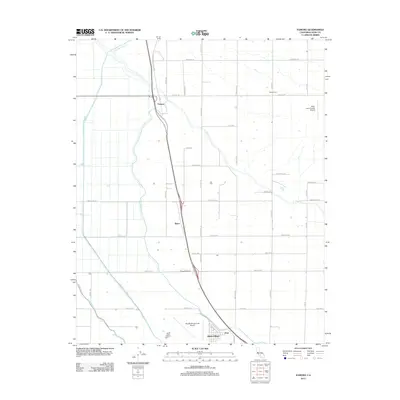
2012 Map of Famoso
USGS Topo · Published 2012About this map
Agricultural operations and water management systems define this portion of the San Joaquin Valley north of Bakersfield. The Friant-Kern Canal and Lerdo Canal cut through the landscape, supporting the industrial-scale farming indicated by the presence of Doyle Ranch and Kimberlina Ranch. The small community of Famoso sits at the junction of the Famoso Porterville Hwy and local rail lines, serving as a primary transit point for the region. To the south, aviation history and local industry converge near the Shafter-Minter Field Airport and Minter Village, while the settlement of Slater remains a distinct marker along the highway corridor. This area showcases the 21st-century evolution of California's Central Valley, where the natural course of Poso Cr has been integrated into a complex network of man-made irrigation channels like the Calloway Canal.
Find a feature on this map
39 named features on this map. Tap any name to fly to it.
Don’t see what you’re looking for? This feature index may not catch every label — zoom into the map to look around manually.
Map Details
Editions of this 2012 Famoso Map
This is the sole edition of this map. No revisions or reprints were ever made.
Other maps of this area

1906 · Bakersfield
USGS Topo · 1:62,500

1910 · Buena Vista Lake
USGS Topo · 1:125,000

1912 · Buena Vista Lake
USGS Topo · 1:125,000

1927 · McFarland
USGS Topo · 1:31,680

1930 · McFarland
USGS Topo · 1:31,680

1930 · Wasco
USGS Topo · 1:31,680

1930 · Pond
USGS Topo · 1:31,680

1930 · Famoso
USGS Topo · 1:31,680

1930 · Rosedale
USGS Topo · 1:31,680

1930 · Oildale
USGS Topo · 1:31,680