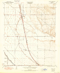
1950 Map of Famoso
USGS Topo · Published 1950About this map
Famoso serves as the central hub of this Central Valley agricultural landscape, situated at the junction where Wasco Road and Woody Road meet the Golden State Highway. The map illustrates a highly organized irrigation and transport network essential to the region's mid-century development. The Southern Pacific railroad runs parallel to the main highway, connecting small siding settlements and agricultural stops such as Slater, Kimberlina, and Dow. Water management is prominent throughout the quadrangle, with the engineered paths of the Lerdo Canal and Calloway Canal cutting across the terrain to support the surrounding fields. In contrast to these straight human-made channels, the meandering course of Poso Creek winds through the eastern hills, showing the natural drainage patterns that precede the intensive irrigation systems of the valley floor.
Find a feature on this map
11 named features on this map. Tap any name to fly to it.
Don’t see what you’re looking for? This feature index may not catch every label — zoom into the map to look around manually.
Map Details
Editions of this 1950 Famoso Map
This is the sole edition of this map. No revisions or reprints were ever made.
Other maps of this area

1906 · Bakersfield
USGS Topo · 1:62,500

1910 · Buena Vista Lake
USGS Topo · 1:125,000

1912 · Buena Vista Lake
USGS Topo · 1:125,000

1927 · McFarland
USGS Topo · 1:31,680

1930 · McFarland
USGS Topo · 1:31,680

1930 · Wasco
USGS Topo · 1:31,680

1930 · Pond
USGS Topo · 1:31,680

1930 · Famoso
USGS Topo · 1:31,680

1930 · Rosedale
USGS Topo · 1:31,680

1930 · Oildale
USGS Topo · 1:31,680