
1968 Map of Fan Lake
USGS Topo · Published 1981About this map
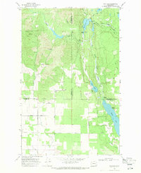
The Little Spokane River winds through this landscape on the Stevens and Spokane county line as it appeared in the late 1960s. The terrain is characterized by the narrow valley of Beaver Creek and the localized industrial activity at the Claypit. This survey, updated with revisions from 1977, captures a moment of transition where the natural waterways dictate the location of rural infrastructure and small-scale operations. The interplay between the river's path and the development of the Claypit suggests the importance of local resources to the surrounding community during this era.
Find a feature on this map
3 named features on this map. Tap any name to fly to it.
Don’t see what you’re looking for? This feature index may not catch every label — zoom into the map to look around manually.
Map Details
Editions of this 1968 Fan Lake Map
2 editions found
Other maps of this area

1901 · Spokane
USGS Topo · 1:125,000

1927 · Chewelah
USGS Topo · 1:125,000

1930 · Chewelah
USGS Topo · 1:125,000

1936 · Newport
USGS Topo · 1:96,000

1942 · Newport
USGS Topo · 1:125,000

1944 · Clayton
USGS Topo · 1:62,500

1949 · Deer Park
USGS Topo · 1:62,500

1950 · Clayton
USGS Topo · 1:62,500
1951 · Deer Park
USGS Topo · 1:62,500

1955 · Spokane
USGS Topo · 1:250,000