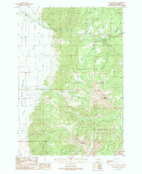
1988 Map of Fan Mountain
USGS Topo · Published 1989About this map
Fan Mountain dominates the high topography of the Madison Range in this late-1980s topographic record. The landscape is defined by the dramatic transition from the steep eastern slopes of the Beaverhead National Forest and the protected Lee Metcalf Wilderness down toward the broad Alluvial Fan to the west. This geological feature is dissected by numerous drainages, including Cedar Creek, which is tapped by the Cedar Creek Aqueduct, suggesting a sophisticated water management system for the lower-elevation valley. Local history is anchored by family-named landmarks and small-scale operations, such as the McDeed, Shell, and Tolman sites along the western margin. These settlements and the network of 4WD trails and footbridges indicate a period when recreational access at the Jack Creek Recreation Site and resource management through Gaging Stations and gravel pits shaped the area's development.
Find a feature on this map
27 named features on this map. Tap any name to fly to it.
Don’t see what you’re looking for? This feature index may not catch every label — zoom into the map to look around manually.
Map Details
Editions of this 1988 Fan Mountain Map
This is the sole edition of this map. No revisions or reprints were ever made.
Other maps of this area

1888 · Three Forks
USGS Topo · 1:250,000

1894 · Three Forks
USGS Topo · 1:250,000

1895 · Three Forks
USGS Topo · 1:250,000

1947 · Bozeman
USGS Topo · 1:250,000

1948 · Bozeman
USGS Topo · 1:250,000

1949 · Ennis
USGS Topo · 1:62,500

1950 · Cameron
USGS Topo · 1:62,500

1950 · Spanish Peaks
USGS Topo · 1:62,500

1950 · Sphinx Mountain
USGS Topo · 1:62,500

1955 · Bozeman
USGS Topo · 1:250,000