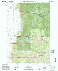
1997 Map of Fan Mountain
USGS Topo · Published 2002About this map
Fan Mountain dominates the eastern high country of this 1997 revision, casting its shadow over the Lee Metcalf Wilderness and the dense timber of Beaverhead National Forest. This Madison County landscape transitions from the high peaks down into the broad valley floors where Fan Alluvial Creek and Cedar Creek define the local hydrology. The human footprint is marked by long-standing operations like the H Lany B Ranch, Diamond J Ranch, and Cedar Creek Ranch, which emphasize the area's ranching heritage. Utility and recreation are mapped in detail, showing a Gaging Station and Aqueduct alongside the Jack Creek Recreation Site. These features reveal a managed wilderness where mountain water is carefully directed for agricultural use below. Geologic activity is noted at several Gravel Pits and a designated Mine, reflecting the mineral extraction common in the Montana backcountry.
Find a feature on this map
24 named features on this map. Tap any name to fly to it.
Don’t see what you’re looking for? This feature index may not catch every label — zoom into the map to look around manually.
Map Details
Editions of this 1997 Fan Mountain Map
This is the sole edition of this map. No revisions or reprints were ever made.
Other maps of this area

1888 · Three Forks
USGS Topo · 1:250,000

1894 · Three Forks
USGS Topo · 1:250,000

1895 · Three Forks
USGS Topo · 1:250,000

1947 · Bozeman
USGS Topo · 1:250,000

1948 · Bozeman
USGS Topo · 1:250,000

1949 · Ennis
USGS Topo · 1:62,500

1950 · Cameron
USGS Topo · 1:62,500

1950 · Spanish Peaks
USGS Topo · 1:62,500

1950 · Sphinx Mountain
USGS Topo · 1:62,500

1955 · Bozeman
USGS Topo · 1:250,000