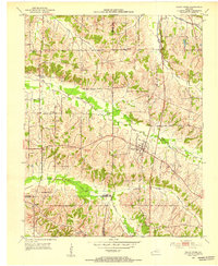
1952 Map of Fancy Farm
USGS Topo · Published 1953About this map
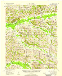
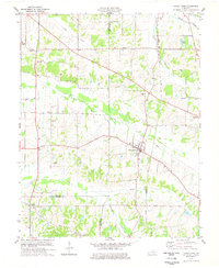
Fancy Farm serves as the focal point of this agricultural landscape in the early 1950s, situated at the junction of local roads and the Illinois Central railroad. The map documents a rural community structure defined by its parish and school sites, such as St Denis Sch and the neighboring St Denis Cem. The drainage patterns of the West Fork Mayfield Creek and its many tributaries, including Goose Creek and Lick Creek, carve through the rolling terrain, influencing the placement of settlements like Kirbyton and St Charles. To the south and west, the map captures the intersection of several county lines, where Beulah sits near the border of Graves, Carlisle, and Hickman counties. For genealogists, the inclusion of specific landmarks like Emmaus Ch and Dodson Cem provides a precise spatial record of family and community life in this portion of Western Kentucky before modern development altered the road networks.
Find a feature on this map
24 named features on this map. Tap any name to fly to it.
Don’t see what you’re looking for? This feature index may not catch every label — zoom into the map to look around manually.
Map Details
Editions of this 1952 Fancy Farm Map
This is the sole edition of this map. No revisions or reprints were ever made.
Historical Maps of Beulah Through Time
8 maps found