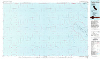
1985 Map of Farallon Islands
USGS Topo · Published 1985About this map
The Farallon Islands emerge from the Pacific Ocean in this mid-1980s planimetric study, documenting the maritime boundaries and landforms off the coast of San Francisco Co. This map emphasizes the isolation of the archipelago, dominated by the Farallon National Wildlife Refuge and the State Game Refuge. The cartography details specific rocky outcrops including North Farallon, Middle Farallon, and the primary landmass at Southeast Farallon. A specialized Coast Guard Reservation is noted on the islands, highlighting their historical and ongoing importance for coastal navigation and surveillance. The inclusion of offshore protraction survey data, shown as a grid across the Gulf of the Farallones, reflects the era's focus on maritime resource management and boundary definition near Noonday Rock.
Find a feature on this map
16 named features on this map. Tap any name to fly to it.
Don’t see what you’re looking for? This feature index may not catch every label — zoom into the map to look around manually.
Map Details
Editions of this 1985 Farallon Islands Map
This is the sole edition of this map. No revisions or reprints were ever made.
Other maps of this area

1916 · Point Reyes
USGS Topo · 1:48,000

1918 · Point Reyes
USGS Topo · 1:62,500

1947 · Santa Rosa
USGS Topo · 1:250,000

1947 · San Francisco
USGS Topo · 1:250,000

1948 · San Francisco
USGS Topo · 1:250,000

1949 · Santa Rosa
USGS Topo · 1:250,000

1953 · Drakes Bay
USGS Topo · 1:24,000
1954 · Point Reyes
USGS Topo · 1:62,500

1955 · San Francisco
USGS Topo · 1:250,000

1956 · San Francisco
USGS Topo · 1:250,000