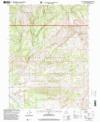
1996 Map of Farm Creek Peak
USGS Topo · Published 2000About this map
Ashley National Forest and the Uintah and Ouray Indian Reservation meet across this mountainous landscape in Duchesne County. The topography is defined by high-elevation drainage systems, where the Right Fork Farm Creek and East Fork Farm Creek descend through deep cuts like Rough Canyon and Cottonwood Hollow. In the lower elevations to the southwest, a complex network of man-made irrigation channels, including the Tabby Canal, Pike Canal, and Jasper Canal, redirects water for agricultural use, contrasting with the wilderness character of the high basins. Genealogists and historians may note the remote Round Grove settlement and several family-named features like Jepp Thomas Canal. Notable summits and landmarks such as Farm Creek Peak and the high-altitude Rock Lake provide essential navigation points within the northern forest sections.
Find a feature on this map
33 named features on this map. Tap any name to fly to it.
Don’t see what you’re looking for? This feature index may not catch every label — zoom into the map to look around manually.
Map Details
Editions of this 1996 Farm Creek Peak Map
This is the sole edition of this map. No revisions or reprints were ever made.
Other maps of this area

1885 · Uinta
USGS Topo · 1:250,000

1901 · Hayden Peak
USGS Topo · 1:125,000

1903 · Hayden Peak
USGS Topo · 1:125,000

1954 · Salt Lake City
USGS Topo · 1:250,000

1958 · Salt Lake City
USGS Topo · 1:250,000

1960 · Salt Lake City
USGS Topo · 1:250,000

1962 · Blacktail Mtn
USGS Topo · 1:24,000

1962 · Hanna
USGS Topo · 1:24,000

1962 · Tabiona
USGS Topo · 1:24,000
1962 · Tabby Mountain
USGS Topo · 1:24,000