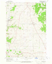
1965 Map of Farmersburg
USGS Topo · Published 1966About this map
The Chicago Milwaukee St Paul and Pacific railroad cuts through the northwestern corner of this Clayton County landscape, serving the community of Farmersburg. This mid-1960s survey captures a rural environment defined by a network of creeks and valleys, most notably Mill Creek and the deep incision of Dry Hollow. While agriculture remains the primary footprint, the map documents several civic and community focal points including the County Fairground near National and the County Farm further south. Genealogists will find particular value in the documentation of local burial grounds such as National Cem, Giard Cem, and the Farmersburg-Wagner Cem. The settlement at Clayton Center anchors the southern portion of the sheet, where a Radio Tower and several quarries suggest the local utility and industrial activities of the era.
Find a feature on this map
26 named features on this map. Tap any name to fly to it.
Don’t see what you’re looking for? This feature index may not catch every label — zoom into the map to look around manually.
Map Details
Editions of this 1965 Farmersburg Map
This is the sole edition of this map. No revisions or reprints were ever made.
Other maps of this area

1902 · Elkader
USGS Topo · 1:125,000

1903 · Waukon
USGS Topo · 1:125,000

1929 · Prairie Du Chien
USGS Topo · 1:62,500

1932 · Prairie Du Chien
USGS Topo · 1:62,500

1958 · La Crosse
USGS Topo · 1:250,000

1959 · Dubuque
USGS Topo · 1:250,000

1961 · Dubuque
USGS Topo · 1:250,000

1961 · La Crosse
USGS Topo · 1:250,000

1962 · Dubuque
USGS Topo · 1:250,000

1962 · Clayton
USGS Topo · 1:24,000