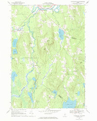
1968 Map of Farmington Falls
USGS Topo · Published 1971About this map
The Sandy River winds through the northern reaches of this landscape, marking the historic center of Farmington Falls at the border of Farmington and New Sharon. This late 1960s survey reveals a rural Maine interior defined by an intricate network of water bodies and family-named landmarks. The terrain transitions from the elevations of Cape Cod Hill and Zion Hill down to a dense cluster of ponds, including Crowell Pond, Norcross Pond, and Parker Pond, connected by meandering waterways like Little Norridgewock Stream and McCurdy Stream.
Find a feature on this map
55 named features on this map. Tap any name to fly to it.
Don’t see what you’re looking for? This feature index may not catch every label — zoom into the map to look around manually.
Map Details
Editions of this 1968 Farmington Falls Map
This is the sole edition of this map. No revisions or reprints were ever made.
Other maps of this area

1892 · Augusta
USGS Topo · 1:62,500

1894 · Norridgewock
USGS Topo · 1:62,500

1898 · Norridgewock
USGS Topo · 1:62,500

1910 · Livermore
USGS Topo · 1:62,500

1912 · Livermore
USGS Topo · 1:62,500

1924 · Farmington
USGS Topo · 1:62,500

1941 · Livermore
USGS Topo · 1:62,500

1941 · Augusta
USGS Topo · 1:62,500

1943 · Augusta
USGS Topo · 1:62,500

1943 · Norridgewock
USGS Topo · 1:62,500