Loading...
Loading map...1980 Map of Farmington
USGS Topo · Published 1981About this map
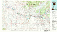
The confluence of the San Juan River and Animas River at Farmington serves as the focal point for this 1980 survey of Northwest New Mexico. The landscape reveals a complex mix of industrial development and ancestral lands, characterized by the massive Navajo Mine and the Four Corners Powerplant located south of Fruitland. These energy operations contrast with the stark natural landmarks that define the region, such as the geological spine of The Hogback and the iconic spire of Ship Rock.
Find a feature on this map
47 named features on this map. Tap any name to fly to it.
Don’t see what you’re looking for? This feature index may not catch every label — zoom into the map to look around manually.
Map Details
Date Portrayed1980
Date Published1981
PublisherU.S. Geological Survey
Map TypeTopographic
Scale1:100,000
Physical Dimensions42.1 x 24.1 inches
Editions of this 1980 Farmington Map
2 editions found
Historical Maps of Farmington Through Time
1 maps found
Featured Locations
Source Details
SourceU.S. Geological Survey
CopyrightPublic Domain