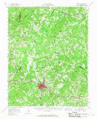
1958 Map of Farmville
USGS Topo · Published 1968About this map
Farmville serves as the focal point of this Central Virginia landscape, showing the town at the intersection of the Appomattox River and the Norfolk and Western railway. The presence of Longwood College and schools such as Moton Sch and Jackson High Sch highlight the educational infrastructure of Prince Edward County during the late 1950s. The terrain transitions from the concentrated grid of the town to the dense woodlands of Cumberland State Forest in the northeast, where the Willis River and Tear Wallet Creek drain the countryside. Significant engineering landmarks are visible, most notably the High Bridge spanning the Appomattox. Rural life is anchored by established crossroads like Raines Tavern, Curdsville, and Rice, while the Colonial Trail and numerous country churches, such as Mt Moriah Ch and Antioch Ch, provide clear markers for tracing local genealogy and settlement patterns.
Find a feature on this map
109 named features on this map. Tap any name to fly to it.
Don’t see what you’re looking for? This feature index may not catch every label — zoom into the map to look around manually.
Map Details
Editions of this 1958 Farmville Map
2 editions found

Other maps of this area

1891 · Palmyra
USGS Topo · 1:125,000

1891 · Farmville
USGS Topo · 1:125,000

1892 · Buckingham
USGS Topo · 1:125,000

1892 · Appomattox
USGS Topo · 1:125,000

1893 · Farmville
USGS Topo · 1:125,000

1895 · Palmyra
USGS Topo · 1:125,000

1897 · Palmyra
USGS Topo · 1:125,000

1947 · Roanoke
USGS Topo · 1:250,000

1950 · Dillwyn
USGS Topo · 1:62,500

1956 · Charlotte Court House
USGS Topo · 1:62,500