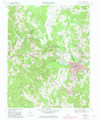
1968 Map of Farmville
USGS Topo · Published 1982About this map
Longwood College serves as a prominent educational anchor in the town of Farmville, situated at the convergence of the Appomattox River and the Norfolk and Western railway. This 1960s-era topography, updated with early 1980s developments, reveals a landscape where traditional crossroads like Raines Tavern and rural congregations such as Oak Grove Ch and Mt Moriah Ch meet modern municipal growth.
Find a feature on this map
50 named features on this map. Tap any name to fly to it.
Don’t see what you’re looking for? This feature index may not catch every label — zoom into the map to look around manually.
Map Details
Editions of this 1968 Farmville Map
4 editions found
Other maps of this area

1891 · Farmville
USGS Topo · 1:125,000

1892 · Appomattox
USGS Topo · 1:125,000

1893 · Farmville
USGS Topo · 1:125,000

1947 · Roanoke
USGS Topo · 1:250,000

1956 · Charlotte Court House
USGS Topo · 1:62,500

1958 · Farmville
USGS Topo · 1:62,500

1958 · Keysville
USGS Topo · 1:62,500

1958 · Pamplin City
USGS Topo · 1:62,500

1959 · Roanoke
USGS Topo · 1:250,000

1963 · Roanoke
USGS Topo · 1:250,000