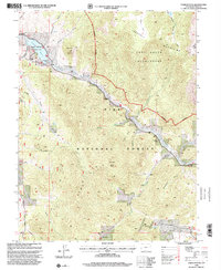
1994 Map of Farnum Peak
USGS Topo · Published 2001About this map
Farnum Peak towers over this section of the Pike National Forest, where the landscape is defined by the high elevations of the Tarryall Mountains and the Puma Hills. The northern reach of the map features the Tarryall Reservoir State Wildlife Area, where Tarryall Creek flows past Rock Point. This 1994 revision shows a mix of recreational and ranching land use, including the Lazy River Ranch and the open spaces of Webber Park and Burns Park. Genealogists and local historians may find interest in the isolated Cem located near the creek, as well as the path of the historical Ute Trail. The geography is intricately carved by numerous drainages such as Graveyard Gulch, Potato Gulch, and Gooseberry Gulch, illustrating the complex water systems feeding into the Lost Creek Wilderness.
Find a feature on this map
30 named features on this map. Tap any name to fly to it.
Don’t see what you’re looking for? This feature index may not catch every label — zoom into the map to look around manually.
Map Details
Editions of this 1994 Farnum Peak Map
This is the sole edition of this map. No revisions or reprints were ever made.
Other maps of this area

1893 · Platte Canyon
USGS Topo · 1:125,000

1953 · Denver
USGS Topo · 1:250,000
1954 · Windy Peak
USGS Topo · 1:24,000

1956 · Eagle Rock
USGS Topo · 1:24,000

1956 · Mc Curdy Mountain
USGS Topo · 1:24,000

1956 · Tarryall
USGS Topo · 1:24,000

1956 · Sulphur Mountain
USGS Topo · 1:24,000

1956 · Farnum Peak
USGS Topo · 1:24,000

1956 · Glentivar
USGS Topo · 1:24,000

1957 · Denver
USGS Topo · 1:250,000