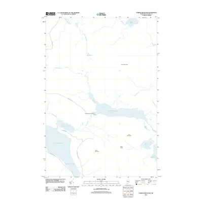
2011 Map of Farrar Mountain
USGS Topo · Published 2011About this map
Medawisla sits at the heart of this Piscataquis County landscape, positioned near the Second Roach Pond Dam where the waters of the Roach River connect a chain of significant ponds. The terrain is defined by a series of prominent peaks and ridges, including Farrar Mountain, Trout Mountain, and Shaw Mountain, which overlook the expansive First Roach Pond and Second Roach Pond. This area of Maine is characterized by its complex network of waterways, where Bear Pond Brook and Hinckley Brook drain the high ground. The infrastructure reflects a wilderness-focused layout, with routes like Roach Pond Rd and Frenchtown Rd providing the primary access to these remote water bodies and the logging or recreational camps that have long defined the region's human geography.
Find a feature on this map
24 named features on this map. Tap any name to fly to it.
Don’t see what you’re looking for? This feature index may not catch every label — zoom into the map to look around manually.
Map Details
Editions of this 2011 Farrar Mountain Map
This is the sole edition of this map. No revisions or reprints were ever made.
Other maps of this area

1952 · Jo-Mary Mountain
USGS Topo · 1:62,500

1952 · First Roach Pond
USGS Topo · 1:62,500

1954 · Grant Farm
USGS Topo · 1:62,500

1954 · Harrington Lake
USGS Topo · 1:62,500

1954 · Millinocket
USGS Topo · 1:250,000

1958 · Millinocket
USGS Topo · 1:250,000

1960 · Millinocket
USGS Topo · 1:250,000
1977 · Big Spencer Mountain
USGS Topo · 1:24,000
1977 · Number Four Mountain
USGS Topo · 1:24,000
1977 · Kokadjo
USGS Topo · 1:24,000