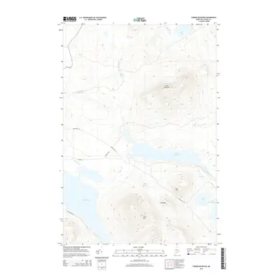
2014 Map of Farrar Mountain
USGS Topo · Published 2014About this map
Second Roach Pond and the surrounding wilderness of Piscataquis County dominate this 2014 survey, highlighting a landscape defined by interconnected waterways and steep peaks. The Roach River serves as a central artery, flowing through a series of namesake basins including First Roach Pond and Fourth Roach Pond. These waters are hemmed in by significant elevations such as Shaw Mtn, Trout Mtn, and the namesake Farrar Mountain.
Find a feature on this map
22 named features on this map. Tap any name to fly to it.
Don’t see what you’re looking for? This feature index may not catch every label — zoom into the map to look around manually.
Map Details
Editions of this 2014 Farrar Mountain Map
This is the sole edition of this map. No revisions or reprints were ever made.
Other maps of this area

1952 · Jo-Mary Mountain
USGS Topo · 1:62,500

1952 · First Roach Pond
USGS Topo · 1:62,500

1954 · Grant Farm
USGS Topo · 1:62,500

1954 · Harrington Lake
USGS Topo · 1:62,500

1954 · Millinocket
USGS Topo · 1:250,000

1958 · Millinocket
USGS Topo · 1:250,000

1960 · Millinocket
USGS Topo · 1:250,000
1977 · Big Spencer Mountain
USGS Topo · 1:24,000
1977 · Number Four Mountain
USGS Topo · 1:24,000
1977 · Kokadjo
USGS Topo · 1:24,000