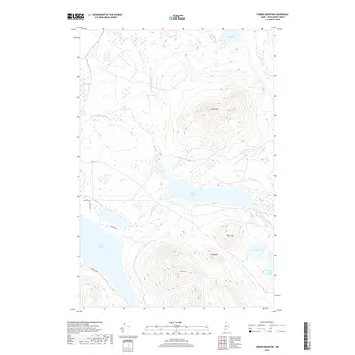
2018 Map of Farrar Mountain
USGS Topo · Published 2018About this map
Farrar Mtn and Shaw Mtn dominate the high ground of Frenchtown Township in this 2018 survey of the North Maine Woods. This landscape is defined by the hydrologic connection of the Roach Pond chain, where the Roach River links Second Roach Pond to First Roach Pond. The terrain shifts from the sharp elevations of Trout Mtn and the extended Long Ridge to the low, saturated environments of Long Bog and the wetlands surrounding Fourth Roach Pond. A network of logging and access roads, including Frenchtown Rd and Peninsula Rd, provides the primary infrastructure through these timberlands. The presence of named features like Hinckley Cove and Black Pond indicates a geography shaped by both glacial activity and the long-standing recreational and industrial use of Piscataquis County's interior waterways.
Find a feature on this map
23 named features on this map. Tap any name to fly to it.
Don’t see what you’re looking for? This feature index may not catch every label — zoom into the map to look around manually.
Map Details
Editions of this 2018 Farrar Mountain Map
This is the sole edition of this map. No revisions or reprints were ever made.
Other maps of this area

1952 · Jo-Mary Mountain
USGS Topo · 1:62,500

1952 · First Roach Pond
USGS Topo · 1:62,500

1954 · Grant Farm
USGS Topo · 1:62,500

1954 · Harrington Lake
USGS Topo · 1:62,500

1954 · Millinocket
USGS Topo · 1:250,000

1958 · Millinocket
USGS Topo · 1:250,000

1960 · Millinocket
USGS Topo · 1:250,000
1977 · Big Spencer Mountain
USGS Topo · 1:24,000
1977 · Number Four Mountain
USGS Topo · 1:24,000
1977 · Kokadjo
USGS Topo · 1:24,000