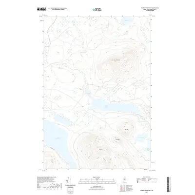
2021 Map of Farrar Mountain
USGS Topo · Published 2021About this map
Farrar Mountain and its neighboring peaks dominate this part of the Maine North Woods, where high-elevation terrain is broken only by an intricate system of glacial water bodies. The landscape is defined by massive landforms like Shaw Mountain and Trout Mountain, which rise sharply above the interconnected waters of Second Roach Pond and the northern reaches of First Roach Pond. The drainage pattern is complex, with Long Bog and Hinckley Cove indicating the saturated, low-lying transitions between these significant water bodies. Human intervention is sparse in this interior wilderness, limited primarily to Frenchtown Road, which provides the only major terrestrial access through the township. Topographic details reveal the prominence of Long Ridge and the isolation of high-country waters like Black Pond and Bear Pond, illustrating the topographic challenges of this Piscataquis County timber and recreation corridor.
Find a feature on this map
13 named features on this map. Tap any name to fly to it.
Don’t see what you’re looking for? This feature index may not catch every label — zoom into the map to look around manually.
Map Details
Editions of this 2021 Farrar Mountain Map
This is the sole edition of this map. No revisions or reprints were ever made.
Other maps of this area

1952 · Jo-Mary Mountain
USGS Topo · 1:62,500

1952 · First Roach Pond
USGS Topo · 1:62,500

1954 · Grant Farm
USGS Topo · 1:62,500

1954 · Harrington Lake
USGS Topo · 1:62,500

1954 · Millinocket
USGS Topo · 1:250,000

1958 · Millinocket
USGS Topo · 1:250,000

1960 · Millinocket
USGS Topo · 1:250,000
1977 · Big Spencer Mountain
USGS Topo · 1:24,000
1977 · Number Four Mountain
USGS Topo · 1:24,000
1977 · Kokadjo
USGS Topo · 1:24,000