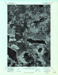
1978 Map of Farrar Mountain
USGS Topo · Published 1981About this map
Second Roach Pond and the headwaters of the Roach River dominate this late-1970s orthophotoquad in the Maine North Woods. This specific document utilizes aerial imagery taken on October 24, 1978, to reveal the raw topography and drainage patterns of the Piscataquis highlands. The landscape is defined by significant elevations, including Farrar Mountain and Trout Mountain, which frame the valley floor. To the southwest, a portion of First Roach Pond appears, connected by the river system to its neighboring basin. Smaller tributaries such as Hinckley Brook and Farrar Brook cut through the forest, showing the intricate hydrological network that feeds these larger glacial ponds. The imagery provides a clear view of the timbered terrain and the winding course of the water as it moves through this sparsely settled region.
Find a feature on this map
8 named features on this map. Tap any name to fly to it.
Don’t see what you’re looking for? This feature index may not catch every label — zoom into the map to look around manually.
Map Details
Editions of this 1978 Farrar Mountain Map
This is the sole edition of this map. No revisions or reprints were ever made.
Other maps of this area

1952 · Jo-Mary Mountain
USGS Topo · 1:62,500

1952 · First Roach Pond
USGS Topo · 1:62,500

1954 · Grant Farm
USGS Topo · 1:62,500

1954 · Harrington Lake
USGS Topo · 1:62,500

1954 · Millinocket
USGS Topo · 1:250,000

1958 · Millinocket
USGS Topo · 1:250,000

1960 · Millinocket
USGS Topo · 1:250,000
1977 · Big Spencer Mountain
USGS Topo · 1:24,000
1977 · Number Four Mountain
USGS Topo · 1:24,000
1977 · Kokadjo
USGS Topo · 1:24,000