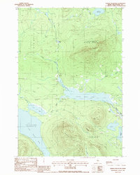
1988 Map of Farrar Mountain
USGS Topo · Published 1988About this map
Farrar Mountain and Shaw Mountain dominate this landscape within the unorganized territories of Piscataquis County, marking the transition between the watershed of First Roach Pond and the more northern Second Roach Pond. The terrain is defined by a dense network of timberlands and water bodies, including Trout Mtn and the winding Roach River which connects these glacial lakes. The presence of a Sand + Gravel Pit near the river indicates the localized industrial use of the land, while numerous named drainages like Bear Pond Brook and Hinckley Brook trace the descent from the peaks into Hinckley Cove. This survey reflects the remote character of Shawtown and Frenchtown during the late twentieth century, showing a region almost entirely dedicated to forestry and wilderness recreation.
Find a feature on this map
25 named features on this map. Tap any name to fly to it.
Don’t see what you’re looking for? This feature index may not catch every label — zoom into the map to look around manually.
Map Details
Editions of this 1988 Farrar Mountain Map
This is the sole edition of this map. No revisions or reprints were ever made.
Other maps of this area

1952 · Jo-Mary Mountain
USGS Topo · 1:62,500

1952 · First Roach Pond
USGS Topo · 1:62,500

1954 · Grant Farm
USGS Topo · 1:62,500

1954 · Harrington Lake
USGS Topo · 1:62,500

1954 · Millinocket
USGS Topo · 1:250,000

1958 · Millinocket
USGS Topo · 1:250,000

1960 · Millinocket
USGS Topo · 1:250,000
1977 · Big Spencer Mountain
USGS Topo · 1:24,000
1977 · Number Four Mountain
USGS Topo · 1:24,000
1977 · Kokadjo
USGS Topo · 1:24,000