1935 Map of Felker
USGS Topo · Published 1935About this map
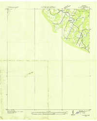
The South Chestuee Creek and Chestuee Creek valleys dominate this portion of Bradley County, reflecting a landscape defined by small-scale rural communities during the mid-1930s. This advance sheet, compiled from early aerial photography by the Tennessee Valley Authority and the Geological Survey, reveals a network of local roads connecting essential social hubs such as Union Grove Ch and the uniquely named Kinsers Tabernacle. Educational and religious landmarks like Taylors Sch and Thompson Springs Ch serve as focal points for the surrounding farmsteads, while topographical markers such as McCann provide specific reference points for researchers. The drainage patterns of Papa Branch and Carson Creek illustrate the natural irrigation that supported this agricultural region before the large-scale changes of later decades.
Find a feature on this map
10 named features on this map. Tap any name to fly to it.
Don’t see what you’re looking for? This feature index may not catch every label — zoom into the map to look around manually.
Map Details
Editions of this 1935 Felker Map
This is the sole edition of this map. No revisions or reprints were ever made.
Other maps of this area

1886 · Dalton
USGS Topo · 1:125,000

1886 · Cleveland
USGS Topo · 1:125,000

1892 · Cleveland
USGS Topo · 1:125,000

1892 · Dalton
USGS Topo · 1:125,000

1895 · Cleveland
USGS Topo · 1:125,000

1897 · Dalton
USGS Topo · 1:125,000

1901 · Cleveland
USGS Topo · 1:125,000
1911 · Cohutta Mtn
USGS Topo · 1:62,500
1913 · Cohutta Mtn.
USGS Topo · 1:62,500
1935 · East Cleveland
USGS Topo · 1:24,000