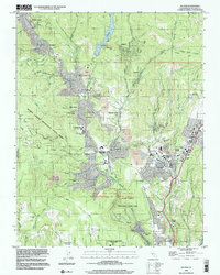
1998 Map of Felton
USGS Topo · Published 2002About this map
The San Lorenzo River valley defines this late 20th-century landscape, threading together the mountain communities of Felton, Ben Lomond, and Boulder Creek. This era reveals a balance between preservation and development, where the expansive Henry Cowell Redwoods State Park and Wilder Ranch State Park border growing residential centers. The map documents the local educational infrastructure with several campuses, including the San Lorenzo Valley High Sch and Quail Hollow Sch.
Find a feature on this map
93 named features on this map. Tap any name to fly to it.
Don’t see what you’re looking for? This feature index may not catch every label — zoom into the map to look around manually.
Map Details
Editions of this 1998 Felton Map
This is the sole edition of this map. No revisions or reprints were ever made.
Other maps of this area

1902 · Santa Cruz
USGS Topo · 1:125,000

1912 · Capitola
USGS Topo · 1:62,500

1914 · Capitola
USGS Topo · 1:62,500

1916 · New Almaden
USGS Topo · 1:48,000

1919 · New Almaden
USGS Topo · 1:62,500
1940 · Capitola
USGS Topo · 1:62,500

1940 · Los Gatos
USGS Topo · 1:62,500

1943 · Los Gatos
USGS Topo · 1:62,500

1947 · San Francisco
USGS Topo · 1:250,000

1947 · San Jose
USGS Topo · 1:250,000