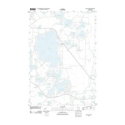
2010 Map of Fence Lake
USGS Topo · Published 2010About this map
Fence Lake dominates the central landscape of this northern Wisconsin lake country, serving as the focal point for a dense network of interconnected waterways and glacial basins. The small settlement of Marlands sits at the lake's eastern shore, marking a point of residential development amidst a terrain defined by complex hydrography. The map details a labyrinth of water bodies including Shishebogama Lake, Gunlock Lake, and the Whitefish Lake system, which are part of a larger aquatic ecosystem drained by the Tomahawk River and Mishonagon Creek. These water features suggest a region shaped by recreational tourism and seasonal residency, where the land-to-water ratio is nearly equal. Local roads navigate the narrow land bridges between basins like Placid Twin Lakes and Wyandock Lake, illustrating how the physical geography of the Lac du Flambeau area dictates modern transport and settlement patterns.
Find a feature on this map
38 named features on this map. Tap any name to fly to it.
Don’t see what you’re looking for? This feature index may not catch every label — zoom into the map to look around manually.
Map Details
Editions of this 2010 Fence Lake Map
This is the sole edition of this map. No revisions or reprints were ever made.
Other maps of this area

1938 · Minocqua
USGS Topo · 1:48,000

1938 · Lac Du Flambeau
USGS Topo · 1:48,000

1939 · Trout Lake
USGS Topo · 1:48,000

1939 · Lac Du Flambeau
USGS Topo · 1:48,000

1939 · Winchester
USGS Topo · 1:48,000

1946 · Winchester
USGS Topo · 1:48,000

1946 · Minocqua
USGS Topo · 1:48,000

1946 · Lac Du Flambeau
USGS Topo · 1:48,000

1946 · Trout Lake
USGS Topo · 1:48,000

1949 · Trout Lake
USGS Topo · 1:48,000