
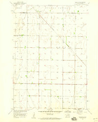
1954 Map of Ferney
USGS Topo · Published 1955About this map
Ferney serves as the central hub of this agricultural landscape in eastern South Dakota during the mid-1950s. The town is situated along the Chicago and North Western railroad line, which bisects the territory and historically provided the vital link for local grain transport. The surrounding prairie is characterized by a high density of small rural schoolhouses, including Prairie Pride Sch, Haywood Sch, and the already School No 266 (Abandoned), illustrating the early consolidation and shifting demographics of rural township education. Water management is a visible priority across the terrain, from the Pigors Dam on Mud Creek to the presence of a Flowing Well and the seasonal path of Dry Run. Local genealogy is anchored by sites like St Pauls Cem and Verdon Cem, which mark the small communities and family farms that defined the area's development.
Find a feature on this map
18 named features on this map. Tap any name to fly to it.
Don’t see what you’re looking for? This feature index may not catch every label — zoom into the map to look around manually.
Map Details
Editions of this 1954 Ferney Map
This is the sole edition of this map. No revisions or reprints were ever made.
Other maps of this area

1894 · Conde
USGS Topo · 1:62,500

1895 · Aberdeen
USGS Topo · 1:125,000

1953 · Groton SW
USGS Topo · 1:24,000

1953 · Milbank
USGS Topo · 1:250,000

1954 · Groton
USGS Topo · 1:24,000

1954 · James
USGS Topo · 1:24,000

1954 · Aberdeen
USGS Topo · 1:250,000

1956 · Aberdeen
USGS Topo · 1:250,000

1958 · Milbank
USGS Topo · 1:250,000
1958 · Randolph
USGS Topo · 1:24,000
Featured Places
- Bates Township, SD
- West Hanson Township, SD
- Garden Prairie Township, SD
- Ferney, SD
- East Hanson Township, SD