
1894 Map of Conde
USGS Topo · Published 1894About this map
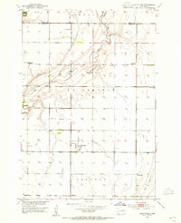
Garden Prairie and La Prairie stretch across this section of the Dakotas, where the early landscape was defined by emerging rail connections and sparse pioneer outposts. Surveyed in 1893, the area shows the critical importance of the Chicago and North-Western Railway, which dictates the placement of towns like Conde, Verdon, and Turton. These settlements formed the commercial backbone for the surrounding agricultural townships, including Beotia, Benton, and Olean.
Find a feature on this map
17 named features on this map. Tap any name to fly to it.
Don’t see what you’re looking for? This feature index may not catch every label — zoom into the map to look around manually.
Map Details
Editions of this 1894 Conde Map
This is the sole edition of this map. No revisions or reprints were ever made.
Other maps of this area

1895 · Byron
USGS Topo · 1:125,000

1895 · Aberdeen
USGS Topo · 1:125,000
1953 · Brentford
USGS Topo · 1:24,000
1953 · Stratford
USGS Topo · 1:24,000
1953 · Frankfort
USGS Topo · 1:24,000

1953 · Groton SW
USGS Topo · 1:24,000

1953 · Milbank
USGS Topo · 1:250,000

1953 · Huron
USGS Topo · 1:250,000

1953 · Watertown
USGS Topo · 1:250,000
1954 · Ferney
USGS Topo · 1:24,000
Featured Places
- Conde, Conde Township
- Turton, Turton Township
- Verdon, Bates Township
- Tetonka Township, SD
- Randolph, Garden Prairie Township