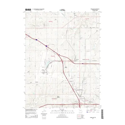
2015 Map of Ferrelview
USGS Topo · Published 2015About this map
Kansas City International Airport dominates the southwestern quadrant of this 2015 survey, illustrating the significant land use requirements of modern aviation infrastructure in Platte Co. The map captures a transition between high-density transport corridors and the agricultural character of the Missouri-Platte region. Smaller residential pockets like Ferrelview, Linkville, and Tarrytown are interspersed with historical family landmarks and burial sites. Genealogists will find a high concentration of cemeteries, including Brasfield Cemetery, Waller Cemetery, Dixon Cemetery, and Pancake Cemetery, scattered across the township lines. The natural drainage of the land is defined by winding tributaries such as Todd Creek and Wildcat Branch, which feed into localized catchments like Berlin Reservoir and Sampson Lake. The presence of Tiffany Springs in the south further highlights the area's historical reliance on natural water sources before large-scale development.
Find a feature on this map
79 named features on this map. Tap any name to fly to it.
Don’t see what you’re looking for? This feature index may not catch every label — zoom into the map to look around manually.
Map Details
Editions of this 2015 Ferrelview Map
This is the sole edition of this map. No revisions or reprints were ever made.
Other maps of this area

1890 · Kansas City
USGS Topo · 1:125,000

1894 · Kansas City
USGS Topo · 1:125,000

1910 · Leavenworth
USGS Topo · 1:62,500

1914 · Smithville
USGS Topo · 1:62,500

1934 · Bonner Springs
USGS Topo · 1:48,000

1934 · Wolcott
USGS Topo · 1:24,000

1935 · North Kansas City
USGS Topo · 1:24,000

1940 · Bonner Springs
USGS Topo · 1:62,500
1940 · North Kansas City
USGS Topo · 1:31,680
1943 · Quindaro
USGS Topo · 1:31,680