1943 Map of Quindaro
USGS Topo · Published 1943About this map
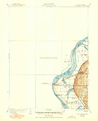
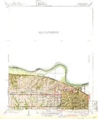
Western University (Old Kansas City University) stands as a prominent landmark on this mid-century map, reflecting the institutional history of the area near the Missouri River bend. The terrain is marked by sharp relief, where Malone Hollow and various creek drainages like Nearman Creek and Muncie Creek drop toward the river valley. Transportation networks are particularly dense, featuring the Kansas City and Leavenworth Electric Road alongside heavy rail lines including the Missouri Pacific and Chicago Great Western. The map documents a period of suburban expansion with small settlements like Nearman, Welborn, and Brenner Heights interspersed with essential local services like Vance Sch and Grandview Ch. The presence of the Municipal Light and Water Plant near the riverbank underscores the infrastructure supporting the growing population of Wyandotte County.
Find a feature on this map
30 named features on this map. Tap any name to fly to it.
Don’t see what you’re looking for? This feature index may not catch every label — zoom into the map to look around manually.
Map Details
Editions of this 1943 Quindaro Map
This is the sole edition of this map. No revisions or reprints were ever made.