
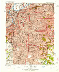
1935 Map of Kansas City
USGS Topo · Published 1935About this map
Union Station stands at the heart of this mid-1930s urban landscape, serving as a hub for the Kansas City Terminal and Kansas City Southern railroads. The map depicts a densely developed metropolis where civic pride is evident in landmarks like the William Rockhill Nelson Gallery of Art and the newly completed Municipal Auditorium. Along the curves of the Missouri River, the Municipal Landing Field occupies a prominent peninsula, reflecting the city's early role in aviation. Residential patterns are marked by a transition from the established street grids of Kansas City toward outlying areas like Centropolis and Leeds. This era captures the city's extensive school and church infrastructure, from the Wyandotte High Sch to the Catholic Cathedral, alongside recreational spaces like Swope Park and the Blue Hills Golf Course.
Find a feature on this map
111 named features on this map. Tap any name to fly to it.
Don’t see what you’re looking for? This feature index may not catch every label — zoom into the map to look around manually.
Map Details
Editions of this 1935 Kansas City Map
2 editions found
Other maps of this area

1887 · Harrisonville
USGS Topo · 1:125,000

1887 · Olathe
USGS Topo · 1:125,000

1890 · Kansas City
USGS Topo · 1:125,000

1892 · Harrisonville
USGS Topo · 1:125,000

1893 · Olathe
USGS Topo · 1:125,000

1894 · Kansas City
USGS Topo · 1:125,000

1894 · Harrisonville
USGS Topo · 1:125,000

1894 · Independence
USGS Topo · 1:125,000

1934 · Independence
USGS Topo · 1:24,000

1934 · Grandview
USGS Topo · 1:24,000