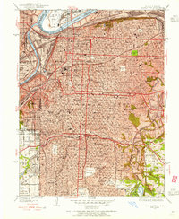
1935 Map of Kansas City
USGS Topo · Published 1955About this map
Union Station serves as the bustling rail hub of this 1930s landscape, where the Missouri River and Kansas River meet. The map reveals a city in its industrial prime, with the massive Stockyards dominating the river bottoms and a dense network of lines including the Kansas City Southern RR and Missouri Pacific RR threading through the urban core. Residential expansion is marked by a vast array of neighborhood schools like Scarritt Sch and Southwest High Sch, alongside significant civic landmarks such as the Liberty Memorial and General Hospital.
Find a feature on this map
117 named features on this map. Tap any name to fly to it.
Don’t see what you’re looking for? This feature index may not catch every label — zoom into the map to look around manually.
Map Details
Editions of this 1935 Kansas City Map
2 editions found

Other maps of this area

1887 · Harrisonville
USGS Topo · 1:125,000

1887 · Olathe
USGS Topo · 1:125,000

1890 · Kansas City
USGS Topo · 1:125,000

1892 · Harrisonville
USGS Topo · 1:125,000

1893 · Olathe
USGS Topo · 1:125,000

1894 · Kansas City
USGS Topo · 1:125,000

1894 · Harrisonville
USGS Topo · 1:125,000

1894 · Independence
USGS Topo · 1:125,000

1934 · Independence
USGS Topo · 1:24,000

1934 · Grandview
USGS Topo · 1:24,000