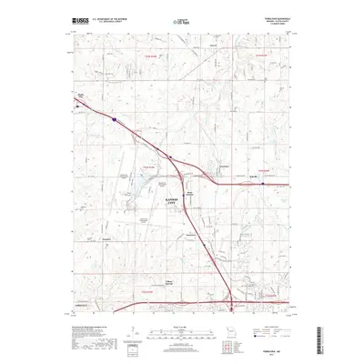
2017 Map of Ferrelview
USGS Topo · Published 2017About this map
Kansas City International Airport dominates the central landscape of this Platte County region, surrounded by a transition from suburban development to rural farmland. The area is marked by numerous family and community burial grounds, including Brasfield Cem and Waller Cem in the north, and Rixey Cem and Hampton Cem further south. These sites, along with small settlements like Hoover and Hampton, provide essential points of reference for genealogists tracing long-established Missouri families.
Find a feature on this map
136 named features on this map. Tap any name to fly to it.
Don’t see what you’re looking for? This feature index may not catch every label — zoom into the map to look around manually.
Map Details
Editions of this 2017 Ferrelview Map
This is the sole edition of this map. No revisions or reprints were ever made.
Other maps of this area

1890 · Kansas City
USGS Topo · 1:125,000

1894 · Kansas City
USGS Topo · 1:125,000

1910 · Leavenworth
USGS Topo · 1:62,500

1914 · Smithville
USGS Topo · 1:62,500

1934 · Bonner Springs
USGS Topo · 1:48,000

1934 · Wolcott
USGS Topo · 1:24,000

1935 · North Kansas City
USGS Topo · 1:24,000

1940 · Bonner Springs
USGS Topo · 1:62,500
1940 · North Kansas City
USGS Topo · 1:31,680
1943 · Quindaro
USGS Topo · 1:31,680