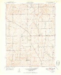
1950 Map of Ferrelview
USGS Topo · Published 1950About this map
Ferrelview and the surrounding rural landscape of Platte County appear as a network of family farms and local schools in the late 1940s. The area is defined by its deep community roots, evidenced by the high density of neighborhood schools such as Park School, Todd Creek School, and Miller School. These small educational hubs served a scattered population connected by winding roads through the Carroll and Pettis townships.
Find a feature on this map
37 named features on this map. Tap any name to fly to it.
Don’t see what you’re looking for? This feature index may not catch every label — zoom into the map to look around manually.
Map Details
Editions of this 1950 Ferrelview Map
2 editions found
Other maps of this area

1890 · Kansas City
USGS Topo · 1:125,000

1894 · Kansas City
USGS Topo · 1:125,000

1910 · Leavenworth
USGS Topo · 1:62,500

1914 · Smithville
USGS Topo · 1:62,500

1934 · Bonner Springs
USGS Topo · 1:48,000

1934 · Wolcott
USGS Topo · 1:24,000

1935 · North Kansas City
USGS Topo · 1:24,000

1940 · Bonner Springs
USGS Topo · 1:62,500
1940 · North Kansas City
USGS Topo · 1:31,680
1943 · Quindaro
USGS Topo · 1:31,680