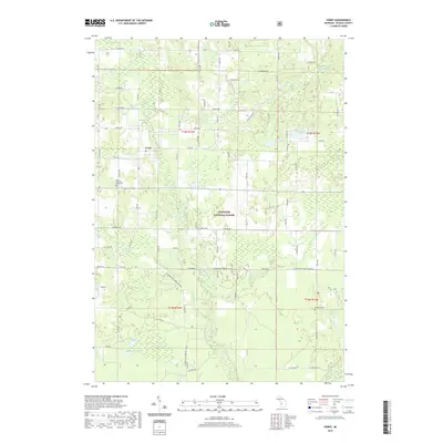
2019 Map of Ferry
USGS Topo · Published 2019About this map
Ferry remains the primary settlement in this corner of Oceana County, situated along the N Br White River and surrounded by the dense woodlands of the Manistee National Forest. The landscape is defined by its glacial hydrology, featuring a complex network of wetlands and small lakes such as Blackmer Lake, Gillon Lake, and Hightower Lake. Broad areas of standing water like Knox Swamp and Lidkey Swamp illustrate the low-lying drainage patterns that have historically influenced road placement and land use in Ferry Township. For local historians and genealogists, the map provides precise locations for three distinct burial grounds: Ferry Township South Cem, Otto Cem, and Woodward Cem. These sites, along with the section-line road grid, reveal the enduring structure of this rural community even as the forest has reclaimed much of the surrounding territory.
Find a feature on this map
42 named features on this map. Tap any name to fly to it.
Don’t see what you’re looking for? This feature index may not catch every label — zoom into the map to look around manually.
Map Details
Editions of this 2019 Ferry Map
This is the sole edition of this map. No revisions or reprints were ever made.
Other maps of this area

1929 · Montague
USGS Topo · 1:48,000

1931 · Hart SE
USGS Topo · 1:31,680

1931 · Walkerville NE
USGS Topo · 1:31,680

1931 · Hart NE
USGS Topo · 1:31,680

1931 · Walkerville SW
USGS Topo · 1:31,680

1931 · Walkerville NW
USGS Topo · 1:31,680

1931 · Walkerville SE
USGS Topo · 1:31,680

1954 · Milwaukee
USGS Topo · 1:250,000

1958 · Milwaukee
USGS Topo · 1:250,000

1958 · Hesperia
USGS Topo · 1:62,500