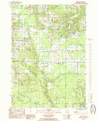
1985 Map of Ferry
USGS Topo · Published 1985About this map
The settlement of Ferry and the nearby Footbridge community are centered in this mid-1980s landscape within the Manistee National Forest. The geography is defined by the White River and its major tributaries, including the North Branch White River, Osborn Creek, and Knutson Creek. A network of wetlands and small lakes like Knox Swamp, Lidkey Swamp, and Hightower Lake suggests a complex glacial terrain that historically influenced local movement and land use. Genealogists and historians can trace the paths of several watercourses and find remnants of former industrial activity such as the Old RR Grade and scattered Gravel Pits. The map also delineates the boundaries of Ferry, Otto, and Green townships, showing the rural development patterns of Oceana County during this era.
Find a feature on this map
27 named features on this map. Tap any name to fly to it.
Don’t see what you’re looking for? This feature index may not catch every label — zoom into the map to look around manually.
Map Details
Editions of this 1985 Ferry Map
This is the sole edition of this map. No revisions or reprints were ever made.
Other maps of this area

1929 · Montague
USGS Topo · 1:48,000

1931 · Hart SE
USGS Topo · 1:31,680

1931 · Walkerville NE
USGS Topo · 1:31,680

1931 · Hart NE
USGS Topo · 1:31,680

1931 · Walkerville SW
USGS Topo · 1:31,680

1931 · Walkerville NW
USGS Topo · 1:31,680

1931 · Walkerville SE
USGS Topo · 1:31,680

1954 · Milwaukee
USGS Topo · 1:250,000

1958 · Milwaukee
USGS Topo · 1:250,000

1958 · Hesperia
USGS Topo · 1:62,500