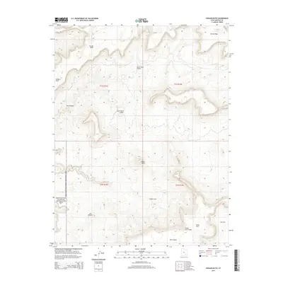
2014 Map of Fiddler Butte
USGS Topo · Published 2014About this map
Glen Canyon National Recreation Area forms the western boundary of this Garfield County landscape, where the high desert meets a complex network of erosional features. The terrain is dominated by The Big Ridge in the north and the prominent spire of Fiddler Butte centrally located. This 2014 survey documents a land of deep drainage systems, including the branching corridors of North Hatch Canyon, South Hatch Canyon, and the main Hatch Canyon. The southeastern portion of the quadrangle descends into Fiddler Cove and Rock Canyon, while Red Benches provides a distinct horizontal break in the vertical topography. The map illustrates the stark geological transition from high plateaus like Buckacre Point to the intricate canyons and blocks, such as South Block, that characterize this part of the Colorado Plateau.
Find a feature on this map
17 named features on this map. Tap any name to fly to it.
Don’t see what you’re looking for? This feature index may not catch every label — zoom into the map to look around manually.
Map Details
Editions of this 2014 Fiddler Butte Map
This is the sole edition of this map. No revisions or reprints were ever made.
Other maps of this area

1885 · San Rafael
USGS Topo · 1:250,000

1886 · Henry Mountains
USGS Topo · 1:250,000

1892 · Henry Mountains
USGS Topo · 1:250,000

1952 · Mouth of Dark Canyon
USGS Topo · 1:62,500

1952 · Orange Cliffs 3 SW
USGS Topo · 1:24,000

1952 · Hite
USGS Topo · 1:62,500

1953 · Orange Cliffs 3 SE
USGS Topo · 1:24,000

1953 · Orange Cliffs 4 NW
USGS Topo · 1:24,000

1953 · Orange Cliffs 3 NE
USGS Topo · 1:24,000

1953 · Orange Cliffs 4 SW
USGS Topo · 1:24,000